
Pineville topographic map
Interactive map
Click on the map to display elevation.
About this map
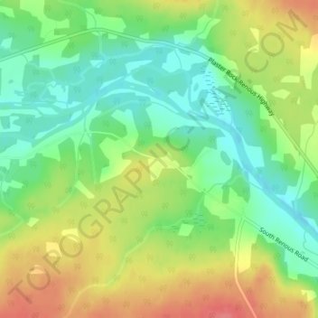
Name: Pineville topographic map, elevation, terrain.
Average elevation: 38 m
Minimum elevation: 7 m
Maximum elevation: 76 m
Other topographic maps
Click on a map to view its topography, its elevation and its terrain.
Tabusintac River
Canada > New Brunswick > Northumberland County
Tabusintac River, Northumberland County, New Brunswick, Canada
Average elevation: 1 m
Glenwood
Canada > New Brunswick > Northumberland County
Glenwood, Glenelg Parish, Northumberland County, New Brunswick, Canada
Average elevation: 39 m
Pleasant Ridge
Canada > New Brunswick > Northumberland County
Pleasant Ridge, Rogersville Parish, Northumberland County, New Brunswick, E4Y 2N2, Canada
Average elevation: 89 m
Tilley Ridge
Canada > New Brunswick > Northumberland County
Tilley Ridge, Northesk Parish, Northumberland County, New Brunswick, Canada
Average elevation: 591 m
Black Point
Canada > New Brunswick > Northumberland County
Black Point, Alnwick Parish, Northumberland County, New Brunswick, Canada
Average elevation: 1 m
Priceville
Canada > New Brunswick > Northumberland County
Priceville, Ludlow Parish, Northumberland County, New Brunswick, Canada
Average elevation: 99 m