
Cottonwood topographic map
Interactive map
Click on the map to display elevation.
About this map
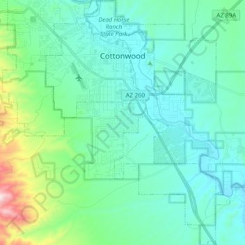
Name: Cottonwood topographic map, elevation, terrain.
Location: Cottonwood, Yavapai County, Arizona, United States (34.65068 -112.05372 34.76554 -111.94872)
Average elevation: 1,118 m
Minimum elevation: 969 m
Maximum elevation: 1,836 m
Other topographic maps
Click on a map to view its topography, its elevation and its terrain.
Prescott
United States > Arizona > Yavapai County
Prescott, Yavapai County, Arizona, United States
Average elevation: 1,674 m
Chino Valley
United States > Arizona > Yavapai County
Chino Valley, Yavapai County, Arizona, 86323, United States
Average elevation: 1,454 m
Black Canyon City
United States > Arizona > Yavapai County
Black Canyon City, Yavapai County, Arizona, 85324, United States
Average elevation: 763 m
Ash Fork
United States > Arizona > Yavapai County > Ash Fork
Ash Fork, Yavapai County, Arizona, 86320, United States
Average elevation: 1,561 m
Prescott Valley
United States > Arizona > Yavapai County
Prescott Valley, Yavapai County, Arizona, United States
Average elevation: 1,550 m
Sedona
United States > Arizona > Yavapai County
Sedona, Yavapai County, Arizona, 86336, United States
Average elevation: 1,342 m