
Bochnia County topographic map
Interactive map
Click on the map to display elevation.
About this map
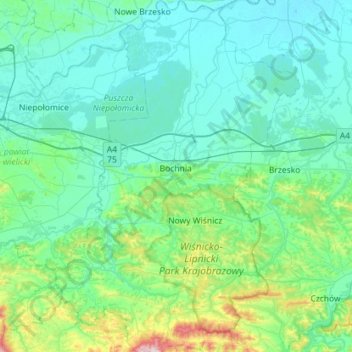
Name: Bochnia County topographic map, elevation, terrain.
Location: Bochnia County, Lesser Poland Voivodeship, Poland (49.77726 20.23248 50.14351 20.63208)
Average elevation: 258 m
Minimum elevation: 176 m
Maximum elevation: 788 m
Other topographic maps
Click on a map to view its topography, its elevation and its terrain.
Łapczyca
Poland > Lesser Poland Voivodeship > Bochnia County
Łapczyca, gmina Bochnia, Bochnia County, Lesser Poland Voivodeship, 32-744, Poland
Average elevation: 262 m
Bochnia
Poland > Lesser Poland Voivodeship > Bochnia County
Bochnia, Bochnia County, Lesser Poland Voivodeship, 32-700, Poland
Average elevation: 234 m
Krakow
Poland > Lesser Poland Voivodeship
Krakow, Lesser Poland Voivodeship, Poland
Average elevation: 258 m
Ptaszkowa
Poland > Lesser Poland Voivodeship > Nowy Sącz County
Ptaszkowa, gmina Grybów, Nowy Sącz County, Lesser Poland Voivodeship, 33-333, Poland
Average elevation: 534 m
Klucze
Poland > Lesser Poland Voivodeship > Olkusz County
Klucze, gmina Klucze, Olkusz County, Lesser Poland Voivodeship, Poland
Average elevation: 348 m
Krynica-Zdrój
Poland > Lesser Poland Voivodeship > Nowy Sącz County
Krynica-Zdrój, gmina Krynica-Zdrój, Nowy Sącz County, Lesser Poland Voivodeship, Poland
Average elevation: 691 m
Mszana Dolna
Poland > Lesser Poland Voivodeship > Limanowa County > Mszana Dolna
Mszana Dolna, Limanowa County, Lesser Poland Voivodeship, 34-730, Poland
Average elevation: 517 m
Krakow
Poland > Lesser Poland Voivodeship
Krakow, Lesser Poland Voivodeship, Poland
Average elevation: 263 m
Jerzmanowice
Poland > Lesser Poland Voivodeship > Kraków County
Jerzmanowice, gmina Jerzmanowice-Przeginia, Kraków County, Lesser Poland Voivodeship, 32-048, Poland
Average elevation: 447 m
Dobranowice
Poland > Lesser Poland Voivodeship > Wieliczka County
Dobranowice, gmina Wieliczka, Wieliczka County, Lesser Poland Voivodeship, Poland
Average elevation: 326 m
Pola
Poland > Lesser Poland Voivodeship > Gorlice County > Binarowa
Pola, Binarowa, gmina Biecz, Gorlice County, Lesser Poland Voivodeship, 38-340, Poland
Average elevation: 316 m
Czchów
Poland > Lesser Poland Voivodeship > Brzesko County
Czchów, gmina Czchów, Brzesko County, Lesser Poland Voivodeship, 32-860, Poland
Average elevation: 294 m
Nowy Sącz
Poland > Lesser Poland Voivodeship > Nowy Sącz
Nowy Sącz, Lesser Poland Voivodeship, 33-300, Poland
Average elevation: 350 m
Zakopane
Poland > Lesser Poland Voivodeship > Tatra County
Zakopane, Tatra County, Lesser Poland Voivodeship, Poland
Average elevation: 1,180 m
Libertów
Poland > Lesser Poland Voivodeship > Kraków County > Libertów
Libertów, gmina Mogilany, Kraków County, Lesser Poland Voivodeship, 30-444, Poland
Average elevation: 270 m
Liszki
Poland > Lesser Poland Voivodeship > Kraków County > Liszki
Liszki, gmina Liszki, Kraków County, Lesser Poland Voivodeship, 32-060, Poland
Average elevation: 232 m
Wielki Giewont
Poland > Lesser Poland Voivodeship > Tatra County > Zakopane
Wielki Giewont, Zakopane, Tatra County, Lesser Poland Voivodeship, Poland
Average elevation: 1,478 m
Kobielnik
Poland > Lesser Poland Voivodeship > Myślenice County > Kobielnik
Kobielnik, gmina Wiśniowa, Myślenice County, Lesser Poland Voivodeship, Poland
Average elevation: 527 m
Brzesko County
Poland > Lesser Poland Voivodeship
Brzesko County, Lesser Poland Voivodeship, Poland
Average elevation: 251 m
Sarnia Skała
Poland > Lesser Poland Voivodeship > Tatra County > Zakopane
Sarnia Skała, Zakopane, Tatra County, Lesser Poland Voivodeship, 34-500, Poland
Average elevation: 1,206 m
Tatra County
Poland > Lesser Poland Voivodeship
Tatra County, Lesser Poland Voivodeship, Poland
Average elevation: 1,105 m
Tatry
Poland > Lesser Poland Voivodeship > Tatra County > Zakopane
Tatry, Zakopane, Tatra County, Lesser Poland Voivodeship, Poland
Average elevation: 1,647 m
Zakopane
Poland > Lesser Poland Voivodeship > Tatra County
Zakopane, Tatra County, Lesser Poland Voivodeship, Poland
Average elevation: 1,180 m
Nowy Targ County
Poland > Lesser Poland Voivodeship
Nowy Targ County, Lesser Poland Voivodeship, Poland
Average elevation: 757 m
Kraków County
Poland > Lesser Poland Voivodeship
Kraków County, Lesser Poland Voivodeship, Poland
Average elevation: 307 m
Szczucin
Poland > Lesser Poland Voivodeship > Szczucin
Szczucin, gmina Szczucin, Dąbrowa County, Lesser Poland Voivodeship, Poland
Average elevation: 167 m
Kaplowa
Poland > Lesser Poland Voivodeship > Witów
Kaplowa, Witów, gmina Kościelisko, Tatra County, Lesser Poland Voivodeship, 34-512, Poland
Average elevation: 941 m
Dąbrowa Tarnowska
Poland > Lesser Poland Voivodeship > Dąbrowa Tarnowska > Dąbrowa Tarnowska
Dąbrowa Tarnowska, gmina Dąbrowa Tarnowska, Dąbrowa County, Lesser Poland Voivodeship, 33-200, Poland
Average elevation: 202 m
Morskie Oko
Poland > Lesser Poland Voivodeship > Brzegi
Morskie Oko, Droga Oswalda Balzera, Brzegi, gmina Bukowina Tatrzańska, powiat tatrzański, Lesser Poland Voivodeship, Poland
Average elevation: 1,749 m
Gorlice County
Poland > Lesser Poland Voivodeship
Gorlice County, Lesser Poland Voivodeship, Poland
Average elevation: 472 m
Nowe Bystre
Poland > Lesser Poland Voivodeship > Nowe Bystre
Nowe Bystre, gmina Poronin, Tatra County, Lesser Poland Voivodeship, Poland
Average elevation: 950 m
Nowy Targ
Poland > Lesser Poland Voivodeship > Nowy Targ > Nowy Targ
Nowy Targ, powiat nowotarski, Lesser Poland Voivodeship, Poland
Average elevation: 679 m
Olkusz
Poland > Lesser Poland Voivodeship > Olkusz County
Olkusz, gmina Olkusz, Olkusz County, Lesser Poland Voivodeship, Poland
Average elevation: 367 m
Gorlice
Poland > Lesser Poland Voivodeship > Gorlice
Gorlice, Gorlice County, Lesser Poland Voivodeship, Poland
Average elevation: 315 m
Oświęcim County
Poland > Lesser Poland Voivodeship
Oświęcim County, Lesser Poland Voivodeship, Poland
Average elevation: 265 m
Wieliczka County
Poland > Lesser Poland Voivodeship
Wieliczka County, Lesser Poland Voivodeship, Poland
Average elevation: 247 m
Limanowa County
Poland > Lesser Poland Voivodeship
Limanowa County, Lesser Poland Voivodeship, Poland
Average elevation: 548 m
Beskidy
Poland > Lesser Poland Voivodeship > Sidzina
Beskidy, Sidzina, gmina Bystra-Sidzina, powiat suski, Lesser Poland Voivodeship, 34-236, Poland
Average elevation: 707 m
Naprawa
Poland > Lesser Poland Voivodeship > Naprawa
Naprawa, gmina Jordanów, powiat suski, Lesser Poland Voivodeship, Poland
Average elevation: 539 m
Krakow
Poland > Lesser Poland Voivodeship > Krakow
Krakow, Lesser Poland Voivodeship, Poland
Average elevation: 263 m
Złoty Potok
Poland > Lesser Poland Voivodeship > Grajów
Złoty Potok, Grajów, gmina Wieliczka, powiat wielicki, Lesser Poland Voivodeship, 32-020, Poland
Average elevation: 335 m
Krakowskie
Poland > Lesser Poland Voivodeship > Krakowskie
Krakowskie, gmina Moszczenica, powiat gorlicki, Lesser Poland Voivodeship, 38-321, Poland
Average elevation: 346 m
Paleśnica
Poland > Lesser Poland Voivodeship > Paleśnica
Paleśnica, gmina Zakliczyn, powiat tarnowski, Lesser Poland Voivodeship, 32-842, Poland
Average elevation: 356 m
Bilczyce
Poland > Lesser Poland Voivodeship > Bilczyce
Bilczyce, gmina Gdów, powiat wielicki, Lesser Poland Voivodeship, Poland
Average elevation: 251 m
Czerna
Poland > Lesser Poland Voivodeship
Czerna, gmina Mucharz, powiat wadowicki, Lesser Poland Voivodeship, 34-106, Poland
Average elevation: 366 m
Nawojowa
Poland > Lesser Poland Voivodeship > Nawojowa
Nawojowa, gmina Nawojowa, powiat nowosądecki, Lesser Poland Voivodeship, 33-335, Poland
Average elevation: 417 m
Pcim
Poland > Lesser Poland Voivodeship > Pcim
Pcim, gmina Pcim, Myślenice County, Lesser Poland Voivodeship, 32-432, Poland
Average elevation: 483 m
Maszyce
Poland > Lesser Poland Voivodeship > Maszyce > Maszyce
Maszyce, gmina Skała, Kraków County, Lesser Poland Voivodeship, Poland
Average elevation: 366 m
Patryja
Poland > Lesser Poland Voivodeship > Patryja
Patryja, gmina Tomice, powiat wadowicki, Lesser Poland Voivodeship, 34-100, Poland
Average elevation: 283 m
Tomanovské sedlo / Tomanowa Przełęcz
Poland > Lesser Poland Voivodeship > Kościelisko
Tomanovské sedlo / Tomanowa Przełęcz, Dolina Małej Łąki, Kościelisko, Zakopane, powiat tatrzański, Lesser Poland Voivodeship, 34-511, Poland
Average elevation: 1,684 m