
Wind Gap topographic map
Interactive map
Click on the map to display elevation.
About this map
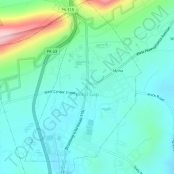
Name: Wind Gap topographic map, elevation, terrain.
Location: Wind Gap, Northampton County, Pennsylvania, United States (40.83493 -75.30521 40.86362 -75.27978)
Average elevation: 255 m
Minimum elevation: 201 m
Maximum elevation: 454 m
Wind Gap is located 21 miles (34 km) north of Allentown in the Lehigh Valley and 50 miles (80 km) southeast of Scranton, in the Wyoming Valley, or the Scranton/Wilkes-Barre metropolitan area. Wind Gap's elevation is 755 feet (230 m) above sea level.
Other topographic maps
Click on a map to view its topography, its elevation and its terrain.
Hartzells Ferry
United States > Pennsylvania > Northampton County > Upper Mount Bethel Township > Hartzells Ferry
Hartzells Ferry, Upper Mount Bethel Township, Northampton County, Pennsylvania, 18343, United States
Average elevation: 144 m