
Lowrys Resurvey topographic map
Interactive map
Click on the map to display elevation.
About this map
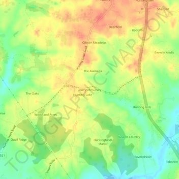
Name: Lowrys Resurvey topographic map, elevation, terrain.
Location: Lowrys Resurvey, Calvert County, Maryland, United States (38.57595 -76.64885 38.61595 -76.60885)
Average elevation: 29 m
Minimum elevation: -2 m
Maximum elevation: 55 m
Other topographic maps
Click on a map to view its topography, its elevation and its terrain.
Chesapeake Beach
United States > Maryland > Calvert County
Chesapeake Beach, Calvert County, Maryland, 20732, United States
Average elevation: 6 m
North Beach
United States > Maryland > Calvert County
North Beach, Calvert County, Maryland, United States
Average elevation: 6 m
Woodridge
United States > Maryland > Calvert County > Prince Frederick > Woodridge
Woodridge, Prince Frederick, Calvert County, Maryland, 20678, United States
Average elevation: 37 m
Crow Haven Estates
United States > Maryland > Calvert County > Crow Haven Estates
Crow Haven Estates, Calvert County, Maryland, 21689, United States
Average elevation: 34 m
Calvert County
United States > Maryland > Calvert County
Calvert County, Maryland, United States
Average elevation: 18 m