
Sirohi topographic map
Interactive map
Click on the map to display elevation.
About this map
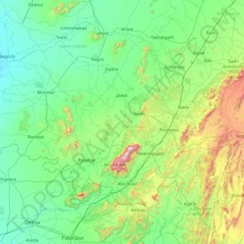
Name: Sirohi topographic map, elevation, terrain.
Location: Sirohi, Sirohi District, Rajasthan, 307001, India (24.13333 72.05000 25.53333 73.45000)
Average elevation: 315 m
Minimum elevation: 68 m
Maximum elevation: 1,659 m
Other topographic maps
Click on a map to view its topography, its elevation and its terrain.
Kotputli
India > Rajasthan > Kotpuli Tehsil
Kotputli, Kotpuli Tehsil, Jaipur District, Rajasthan, 303108, India
Average elevation: 354 m
Malwa
India > Rajasthan > Rohat Tehsil
Malwa, Rohat Tehsil, Pali District, Rajasthan, India
Average elevation: 190 m
Dooni
India > Rajasthan > Dooni Tehsil
Dooni, Dooni Tehsil, Tonk District, Rajasthan, India
Average elevation: 312 m
Saidabad
India > Rajasthan > Tonk Tehsil > Tonk
Saidabad, Tonk, Tonk Tehsil, Tonk District, Rajasthan, 304001, India
Average elevation: 273 m
Deoli
India > Rajasthan > Deoli Tehsil
Deoli, Deoli Tehsil, Tonk District, Rajasthan, 323802, India
Average elevation: 332 m
Rajpura
India > Rajasthan > Shahpura Tehsil
Rajpura, Shahpura Tehsil, Jaipur(Rural) District, Rajasthan, 303103, India
Average elevation: 451 m
Pratapsinghpura
India > Rajasthan > Neemrana Tehsil
Pratapsinghpura, Neemrana Tehsil, Kotputli-Behror District, Rajasthan, 301706, India
Average elevation: 309 m
Tikamsingh ki Dhani
India > Rajasthan > Dechoo Tehsil
Tikamsingh ki Dhani, Dechoo Tehsil, Phalodi District, Rajasthan, India
Average elevation: 285 m
Jodhpur
India > Rajasthan > Jodhpur Tehsil
Jodhpur, Jodhpur Tehsil, Jodhpur District, Rajasthan, India
Average elevation: 238 m
Pirawa
India > Rajasthan > Pirawa Tehsil
Pirawa, Pirawa Tehsil, Jhalawar District, Rajasthan, 326034, India
Average elevation: 384 m
Itawa
India > Rajasthan > Pipalda Tehsil
Itawa, Pipalda Tehsil, Kota District, Rajasthan, 325004, India
Average elevation: 225 m
Pal Kheri
India > Rajasthan > Dungla Tehsil
Pal Kheri, Dungla Tehsil, Chittorgarh District, Rajasthan, 312024, India
Average elevation: 469 m
Talwara
India > Rajasthan > Banswara Tehsil
Talwara, Banswara Tehsil, Banswara District, Rajasthan, 327025, India
Average elevation: 196 m
Chakan
India > Rajasthan > Uniara Tehsil
Chakan, Uniara Tehsil, Tonk District, Rajasthan, India
Average elevation: 248 m
Singhpur
India > Rajasthan > Tijara Tehsil > Banbeerpur
Singhpur, Banbeerpur, Tijara Tehsil, Kherthal-Tijara District, Rajasthan, 318019, India
Average elevation: 266 m
Hirapura
India > Rajasthan > Keshoraipatan Tehsil > Kapren
Hirapura, Kapren, Keshoraipatan Tehsil, Bundi District, Rajasthan, 323301, India
Average elevation: 235 m
Karnisar
India > Rajasthan > Poogal Tehsil
Karnisar, Poogal Tehsil, Bikaner District, Rajasthan, India
Average elevation: 184 m
Begaliyawas
India > Rajasthan > Masuda Tehsil
Begaliyawas, Masuda Tehsil, Beaware District, Rajasthan, India
Average elevation: 448 m
Kolayat
India > Rajasthan > Kolayat Tehsil
Kolayat, Kolayat Tehsil, Bikaner District, Rajasthan, India
Average elevation: 237 m
Banswara
India > Rajasthan > Banswara Tehsil
Banswara, Banswara Tehsil, Banswara District, Rajasthan, 327001, India
Average elevation: 254 m
Shahjahanpur
India > Rajasthan > Neemrana Tehsil
Shahjahanpur, Neemrana Tehsil, Kotputli-Behror District, Rajasthan, 123500, India
Average elevation: 290 m
Sanganer Tehsil
Sanganer Tehsil, Jaipur District, Rajasthan, India
Average elevation: 366 m
Than
India > Rajasthan > Siwana Tehsil
Than, Siwana Tehsil, Barmer District, Rajasthan, India
Average elevation: 218 m
Bhoojela
India > Rajasthan > Pindwara Tehsil
Bhoojela, Pindwara Tehsil, Sirohi District, Rajasthan, India
Average elevation: 295 m
Bagoriya
India > Rajasthan > Bhopalgarh Tehsil
Bagoriya, Bhopalgarh Tehsil, Jodhpur District, Rajasthan, India
Average elevation: 304 m
Kashmir
India > Rajasthan > Sheo Tehsil
Kashmir, Sheo Tehsil, Barmer District, Rajasthan, India
Average elevation: 226 m
Saint
India > Rajasthan > Kumher Tehsil
Saint, Kumher Tehsil, Bharatpur District, Rajasthan, India
Average elevation: 179 m
Kailai
India > Rajasthan > Sikari Tehsil > Koilai
Kailai, Koilai, Sikari Tehsil, Dausa District, Rajasthan, 303508, India
Average elevation: 278 m
21H
India > Rajasthan > Karanpur Tehsil
21H, Karanpur Tehsil, Sri Ganganagar District, Rajasthan, India
Average elevation: 170 m
Gogunda
India > Rajasthan > Gogunda Tehsil
Gogunda, Gogunda Tehsil, Udaipur District, Rajasthan, India
Average elevation: 845 m
Dhoinda
India > Rajasthan > Rajsamand Tehsil
Dhoinda, Rajsamand Tehsil, Rajsamand District, Rajasthan, 313300, India
Average elevation: 548 m
5 ML
India > Rajasthan > Ganganagar Tehsil > Sri Ganganagar
5 ML, Sri Ganganagar, Ganganagar Tehsil, Sri Ganganagar District, Rajasthan, 335001, India
Average elevation: 177 m
Jhajhoo
India > Rajasthan > Kolayat Tehsil
Jhajhoo, Kolayat Tehsil, Bikaner District, Rajasthan, India
Average elevation: 276 m
Kalyanpura
India > Rajasthan > Beejoliya Tehsil
Kalyanpura, Beejoliya Tehsil, Bhilwara District, Rajasthan, 311602, India
Average elevation: 534 m
Kheenvsar
India > Rajasthan > Kheenvsar Tehsil
Kheenvsar, Kheenvsar Tehsil, Nagaur District, Rajasthan, 341025, India
Average elevation: 304 m
Asind
India > Rajasthan > Asind Tehsil
Asind, Asind Tehsil, Bhilwara District, Rajasthan, 311300, India
Average elevation: 479 m
Bikaner
India > Rajasthan > Bikaner Tehsil
Bikaner, Bikaner Tehsil, Bikaner District, Rajasthan, 334001, India
Average elevation: 225 m
Pratapgarh
India > Rajasthan > Pratapgarh Tehsil
Pratapgarh, Pratapgarh Tehsil, Pratapgarh District, Rajasthan, 312605, India
Average elevation: 503 m
Begun
India > Rajasthan > Begun Tehsil
Begun, Begun Tehsil, Chittorgarh District, Rajasthan, 312023, India
Average elevation: 422 m
Pilibanga
India > Rajasthan > Pilibanga Tehsil
Pilibanga, Pilibanga Tehsil, Hanumangarh District, Rajasthan, 335803, India
Average elevation: 179 m
Asop
India > Rajasthan > Bhopalgarh Tehsil
Asop, Bhopalgarh Tehsil, Jodhpur District, Rajasthan, 342900, India
Average elevation: 320 m
Galera
India > Rajasthan > Girwa Tehsil
Galera, Girwa Tehsil, Udaipur District, Rajasthan, India
Average elevation: 670 m
Torda
India > Rajasthan > Bonli Tehsil > Bans Torda
Torda, Bans Torda, Bonli Tehsil, Sawai Madhopur District, Rajasthan, 322023, India
Average elevation: 289 m
Tharla
India > Rajasthan > Digod Tehsil > Kheri Kalya
Tharla, Kheri Kalya, Digod Tehsil, Kota District, Rajasthan, India
Average elevation: 250 m
Chittorgarh
India > Rajasthan > Chittaurgarh Tehsil
Chittorgarh, Chittaurgarh Tehsil, Chittorgarh District, Rajasthan, 312001, India
Average elevation: 442 m
Fatehpur Shekhawati
India > Rajasthan > Fatehpur Tehsil
Fatehpur Shekhawati, Fatehpur Tehsil, Sikar, Rajasthan, 332300, India
Average elevation: 327 m
Kota
India > Rajasthan > Ladpura Tehsil
Kota, Ladpura Tehsil, Kota District, Rajasthan, 324001, India
Average elevation: 286 m
Bassi
India > Rajasthan > Jhadol Tehsil
Bassi, Jhadol Tehsil, Udaipur District, Rajasthan, India
Average elevation: 542 m