
Cap-Pele topographic map
Interactive map
Click on the map to display elevation.
About this map
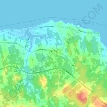
Name: Cap-Pele topographic map, elevation, terrain.
Average elevation: 13 m
Minimum elevation: -2 m
Maximum elevation: 56 m
Other topographic maps
Click on a map to view its topography, its elevation and its terrain.
Hardy
Canada > New Brunswick > Botsford Parish
Hardy, Botsford Parish, Westmorland County, New Brunswick, Canada
Average elevation: 16 m
Bayfield
Canada > New Brunswick > Botsford Parish
Bayfield, Botsford Parish, Westmorland County, New Brunswick, E4M 3Z8, Canada
Average elevation: 7 m
Melrose
Canada > New Brunswick > Botsford Parish
Melrose, Botsford Parish, Westmorland County, New Brunswick, Canada
Average elevation: 33 m
Malden
Canada > New Brunswick > Botsford Parish
Malden, Botsford Parish, Westmorland County, New Brunswick, Canada
Average elevation: 25 m
Shemogue
Canada > New Brunswick > Botsford Parish > Beaubassin East
Shemogue, Beaubassin East, Botsford Parish, Westmorland County, New Brunswick, Canada
Average elevation: 15 m