
Gladeside topographic map
Interactive map
Click on the map to display elevation.
About this map
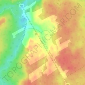
Name: Gladeside topographic map, elevation, terrain.
Average elevation: 71 m
Minimum elevation: 38 m
Maximum elevation: 89 m
Other topographic maps
Click on a map to view its topography, its elevation and its terrain.
Haut-Saint-Antoine
Canada > New Brunswick > Saint Mary Parish
Haut-Saint-Antoine, Saint Mary Parish, Kent County, New Brunswick, E4V 1R3, Canada
Average elevation: 55 m
Saint-Antoine
Canada > New Brunswick > Saint Mary Parish
Saint-Antoine, Saint Mary Parish, Kent County, New Brunswick, Canada
Average elevation: 55 m
Sainte-Marie-de-Kent
Canada > New Brunswick > Saint Mary Parish
Sainte-Marie-de-Kent, Saint Mary Parish, Kent County, New Brunswick, E4S 2E3, Canada
Average elevation: 26 m