
Alandi topographic map
Interactive map
Click on the map to display elevation.
About this map
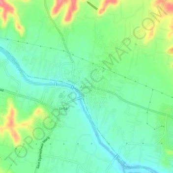
Name: Alandi topographic map, elevation, terrain.
Location: Alandi, Khed, Maharashtra, 412105, India (18.65724 73.87811 18.69724 73.91811)
Average elevation: 578 m
Minimum elevation: 552 m
Maximum elevation: 631 m
Other topographic maps
Click on a map to view its topography, its elevation and its terrain.
Chakan
India > Maharashtra > Khed
Chakan, Khed, Pune, Maharashtra, 410500, India
Average elevation: 624 m
Khed
India > Maharashtra > Khed
Khed, Pune District, Maharashtra, 412205, India
Average elevation: 626 m
Bhima
India > Maharashtra > Khed > Bhorgiri
Bhima, Bhorgiri, Khed, Pune District, Maharashtra, India
Average elevation: 817 m