
Nature Park of Arrábida topographic map
Interactive map
Click on the map to display elevation.
About this map
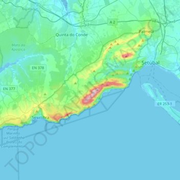
Name: Nature Park of Arrábida topographic map, elevation, terrain.
Location: Nature Park of Arrábida, Setúbal, Portugal (38.39614 -9.23490 38.57036 -8.89734)
Average elevation: 45 m
Minimum elevation: -2 m
Maximum elevation: 485 m
This group is oriented east-northeast to west-southwest, covering an area of about 35 kilometres (22 mi) long and 6 kilometres (3.7 mi) wide, and reaching 501 metres (1,644 ft) at its highest altitude as a result of the Formosinho anticline. Arrábida was formed from four successive phases of rifting that resulted in the fragmentation of Laurasia and the formation of the north Atlantic. This area is unique in the Atlantic for demonstrating the western propagation of the Tethys sea and the formation of the Mediterranean, caused by the collision of the African plate and the Eurasian plate, during the Late Cretaceous. Geologically, the mountainous region was created during the Jurassic and Miocene epochs, while the plains formed during the Pliocene and Quaternary periods. Ribeiro (1935) indicates that the massif began to be formed with successive movements during the Tertiary era.
Other topographic maps
Click on a map to view its topography, its elevation and its terrain.
Colonato de Santo Isidro de Pegões
Portugal > Setúbal > Santo Isidro de Pegões
Colonato de Santo Isidro de Pegões, Santo Isidro de Pegões, Pegões, Montijo, Setúbal, 2985-158, Portugal
Average elevation: 67 m