
Kingsclear topographic map
Interactive map
Click on the map to display elevation.
About this map
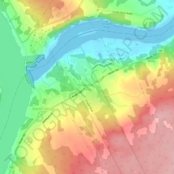
Name: Kingsclear topographic map, elevation, terrain.
Average elevation: 76 m
Minimum elevation: -14 m
Maximum elevation: 164 m
Other topographic maps
Click on a map to view its topography, its elevation and its terrain.
Fredericton
Canada > New Brunswick > Kingsclear Parish > Fredericton
Fredericton, Kingsclear Parish, York County, New Brunswick, Canada
Average elevation: 72 m
Hanwell
Canada > New Brunswick > Kingsclear Parish
Hanwell, Kingsclear Parish, York County, New Brunswick, Canada
Average elevation: 95 m