
Crawford Bay topographic map
Interactive map
Click on the map to display elevation.
About this map
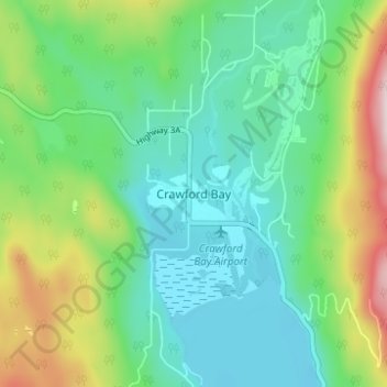
Name: Crawford Bay topographic map, elevation, terrain.
Average elevation: 667 m
Minimum elevation: 524 m
Maximum elevation: 1,030 m
Other topographic maps
Click on a map to view its topography, its elevation and its terrain.
Boswell
Canada > British Columbia > Regional District of Central Kootenay > Area A (Wynndel/Crawford Bay/Riondel)
Boswell, Area A (Wynndel/Crawford Bay/Riondel), Regional District of Central Kootenay, British Columbia, V0B 1A0, Canada
Average elevation: 779 m