
Velva topographic map
Interactive map
Click on the map to display elevation.
About this map
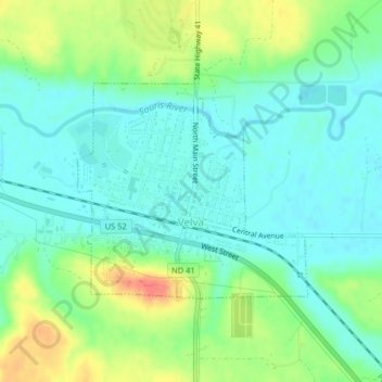
Name: Velva topographic map, elevation, terrain.
Location: Velva, McHenry County, North Dakota, United States (48.05071 -100.94131 48.06595 -100.91689)
Average elevation: 474 m
Minimum elevation: 456 m
Maximum elevation: 510 m
Other topographic maps
Click on a map to view its topography, its elevation and its terrain.
Balfour
United States > North Dakota > McHenry County
Balfour, McHenry County, North Dakota, United States
Average elevation: 488 m
Upham
United States > North Dakota > McHenry County > Upham
Upham, McHenry County, North Dakota, United States
Average elevation: 441 m
Verendrye
United States > North Dakota > McHenry County > Verendrye
Verendrye, McHenry County, North Dakota, 58744, United States
Average elevation: 471 m