
East Lothian topographic map
Interactive map
Click on the map to display elevation.
About this map
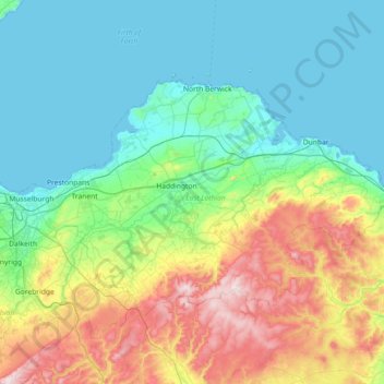
Name: East Lothian topographic map, elevation, terrain.
Location: East Lothian, Scotland, United Kingdom (55.81732 -3.08928 56.07929 -2.36328)
Average elevation: 132 m
Minimum elevation: -7 m
Maximum elevation: 531 m
Other topographic maps
Click on a map to view its topography, its elevation and its terrain.
North Berwick
United Kingdom > Scotland > East Lothian
North Berwick, East Lothian, Scotland, EH39 4HE, United Kingdom
Average elevation: 21 m
Dunbar
United Kingdom > Scotland > East Lothian
Dunbar, East Lothian, Scotland, EH42 1ER, United Kingdom
Average elevation: 24 m