
Columbia Plateau topographic map
Interactive map
Click on the map to display elevation.
About this map
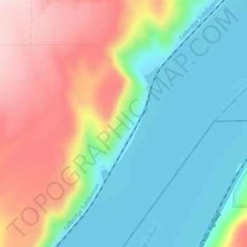
Name: Columbia Plateau topographic map, elevation, terrain.
Location: Columbia Plateau, Benton County, Washington, United States (45.99953 -119.00144 45.99963 -119.00134)
Average elevation: 221 m
Minimum elevation: 102 m
Maximum elevation: 417 m
Other topographic maps
Click on a map to view its topography, its elevation and its terrain.
West Richland
United States > Washington > Benton County
West Richland, Benton County, Washington, 99353, United States
Average elevation: 146 m
Richland
United States > Washington > Benton County
Richland, Benton County, Washington, United States
Average elevation: 160 m
Kennewick
United States > Washington > Benton County
Kennewick, Benton County, Washington, United States
Average elevation: 154 m