
Mauna Loa topographic map
Interactive map
Click on the map to display elevation.
About this map
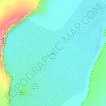
Name: Mauna Loa topographic map, elevation, terrain.
Location: Mauna Loa, Hawaiʻi County, Hawaii, United States (19.47168 -155.59242 19.47178 -155.59232)
Average elevation: 4,012 m
Minimum elevation: 3,965 m
Maximum elevation: 4,184 m
Mauna Loa is the largest subaerial and second largest overall volcano in the world (behind Tamu Massif), covering a land area of 5,271 km2 (2,035 sq mi) and spans a maximum width of 120 km (75 mi). Consisting of approximately 65,000 to 80,000 km3 (15,600 to 19,200 cu mi) of solid rock, it makes up more than half of the surface area of the island of Hawaiʻi. Combining the volcano's extensive submarine flanks (5,000 m (16,400 ft) to the sea floor) and 4,170 m (13,680 ft) subaerial height, Mauna Loa rises 9,170 m (30,085 ft) from base to summit, greater than the 8,848 m or 29,029 ft elevation of Mount Everest from sea level to its summit. In addition, much of the mountain is invisible even underwater: its mass depresses the crust beneath it by another 8 km (5 mi), in the shape of an inverse mountain, meaning the total height of Mauna Loa from the start of its eruptive history is about 17,170 m (56,000 ft).
Other topographic maps
Click on a map to view its topography, its elevation and its terrain.
Kailua CDP
United States > Hawaii > Hawaiʻi County
Kailua CDP, Hawaiʻi County, Hawaii, United States
Average elevation: 321 m
Milolii Bay
United States > Hawaii > Hawaiʻi County > Hoʻōpūloa
Milolii Bay, Hoʻōpūloa, Hawaiʻi County, Hawaii, United States
Average elevation: 31 m
Kailua-Kona
United States > Hawaii > Hawaiʻi County
Kailua-Kona, Hawaiʻi County, Hawaii, 96840, United States
Average elevation: 100 m
Pahoa CDP
United States > Hawaii > Hawaiʻi County
Pahoa CDP, Hawaiʻi County, Hawaii, United States
Average elevation: 192 m
Hilo
United States > Hawaii > Hawaiʻi County > Hilo
Hilo, Hawaiʻi County, Hawaii, United States
Average elevation: 193 m
Mauna Kea
United States > Hawaii > Hawaiʻi County
Mauna Kea, Hawaiʻi County, Hawaii, United States
Average elevation: 3,978 m
Kīlauea
United States > Hawaii > Hawaiʻi County
Kīlauea, Hawaiʻi County, Hawaii, 96718, United States
Average elevation: 1,096 m