
Bayshore topographic map
Interactive map
Click on the map to display elevation.
About this map
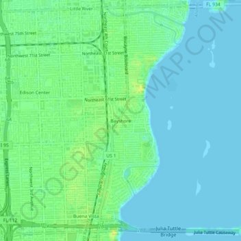
Name: Bayshore topographic map, elevation, terrain.
Location: Bayshore, Miami-Dade County, Florida, 33150:33168, USA (25.80899 -80.20533 25.84899 -80.16533)
Average elevation: 6 m
Minimum elevation: 0 m
Maximum elevation: 17 m
Other topographic maps
Click on a map to view its topography, its elevation and its terrain.
North Fort Myers
United States of America > Florida > Fort Myers > Bayshore
North Fort Myers, Lee County, Florida, United States of America
Average elevation: 7 m