
Pierrefonds topographic map
Interactive map
Click on the map to display elevation.
About this map
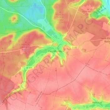
Name: Pierrefonds topographic map, elevation, terrain.
Average elevation: 118 m
Minimum elevation: 52 m
Maximum elevation: 149 m
Other topographic maps
Click on a map to view its topography, its elevation and its terrain.
Chantilly
France > Hauts-de-France > Oise
Chantilly, Senlis, Oise, Hauts-de-France, Metropolitan France, 60500, France
Average elevation: 61 m
Monchy
France > Hauts-de-France > Oise > Rainvillers
Monchy, Rainvillers, Beauvais, Oise, Hauts-de-France, Metropolitan France, 60155, France
Average elevation: 112 m
Saint-Sulpice
France > Hauts-de-France > Oise
Saint-Sulpice, Beauvais, Oise, Hauts-de-France, Metropolitan France, 60430, France
Average elevation: 119 m
Roberval
France > Hauts-de-France > Oise
Roberval, Senlis, Oise, Hauts-de-France, Metropolitan France, 60410, France
Average elevation: 94 m
Clermont
France > Hauts-de-France > Oise
Clermont, Oise, Hauts-de-France, Metropolitan France, 60600, France
Average elevation: 77 m
Chambly
France > Hauts-de-France > Oise
Chambly, Senlis, Oise, Hauts-de-France, Metropolitan France, 60230, France
Average elevation: 65 m