
Espanola topographic map
Interactive map
Click on the map to display elevation.
About this map
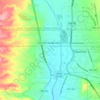
Name: Espanola topographic map, elevation, terrain.
Location: Espanola, Santa Fe County, New Mexico, United States (35.97629 -106.10767 36.03103 -106.03065)
Average elevation: 1,739 m
Minimum elevation: 1,697 m
Maximum elevation: 1,839 m
Española lies at an elevation of around 5,595 feet (1,705 m) with much variance. It is in a valley nestled between the Jemez and Sangre de Cristo mountain ranges, and the meeting point of three rivers, the Rio Grande, the Rio Chama, and the Rio Santa Cruz.
Other topographic maps
Click on a map to view its topography, its elevation and its terrain.
Rancho Viejo
United States > New Mexico > Santa Fe County
Rancho Viejo, Santa Fe County, New Mexico, 87508, United States
Average elevation: 1,994 m
Santa Fe
United States > New Mexico > Santa Fe County
Santa Fe, Santa Fe County, New Mexico, United States
Average elevation: 2,221 m