
Tandil topographic map
Interactive map
Click on the map to display elevation.
About this map
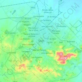
Name: Tandil topographic map, elevation, terrain.
Location: Tandil, Partido de Tandil, Buenos Aires, Argentina (-37.38058 -59.20375 -37.27336 -59.05792)
Average elevation: 228 m
Minimum elevation: 164 m
Maximum elevation: 499 m
Other topographic maps
Click on a map to view its topography, its elevation and its terrain.
Palermo
Argentina > Buenos Aires > Tandil
Palermo, Tandil, Partido de Tandil, Buenos Aires, Argentina
Average elevation: 185 m