
Chattanooga topographic map
Interactive map
Click on the map to display elevation.
About this map
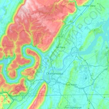
Name: Chattanooga topographic map, elevation, terrain.
Average elevation: 331 m
Minimum elevation: 189 m
Maximum elevation: 722 m
The city, with a downtown elevation of about 680 feet (210 m), is at the transition between the ridge-and-valley portion of the Appalachian Mountains and the Cumberland Plateau. Its official nickname is "Scenic City", alluding to the surrounding by mountains and ridges. Unofficial nicknames include "River City", "Chatt", "Nooga", "Chattown", and "Gig City", the latter a reference to Chattanooga's claims that it has the fastest internet service in the Western Hemisphere.
Other topographic maps
Click on a map to view its topography, its elevation and its terrain.
Signal Mountain
United States > Tennessee > Hamilton County
Signal Mountain, Hamilton County, East Tennessee, Tennessee, 37377, United States
Average elevation: 493 m
East Lake
United States > Tennessee > Hamilton County > Chattanooga > East Ridge
East Lake, East Ridge, Chattanooga, Hamilton County, East Tennessee, Tennessee, 37407, United States
Average elevation: 231 m
Battery Heights
United States > Tennessee > Hamilton County > Chattanooga
Battery Heights, Chattanooga, Hamilton County, Tennessee, 37406, United States
Average elevation: 221 m
Old Farm
United States > Tennessee > Hamilton County > Chattanooga
Old Farm, Chattanooga, Hamilton County, Tennessee, 37419, United States
Average elevation: 261 m
East Brainerd
United States > Tennessee > Hamilton County > Chattanooga
East Brainerd, Chattanooga, Hamilton County, Tennessee, 30726, United States
Average elevation: 225 m
Ooltewah
United States > Tennessee > Hamilton County
Ooltewah, Hamilton County, East Tennessee, Tennessee, United States
Average elevation: 267 m