
Sheguiandah topographic map
Interactive map
Click on the map to display elevation.
About this map
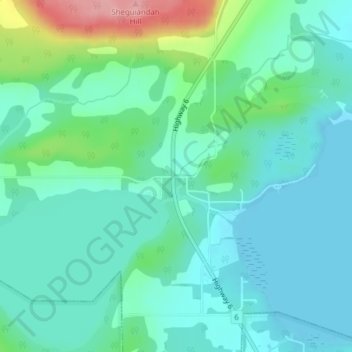
Name: Sheguiandah topographic map, elevation, terrain.
Average elevation: 205 m
Minimum elevation: 175 m
Maximum elevation: 306 m
Other topographic maps
Click on a map to view its topography, its elevation and its terrain.
Northeastern Manitoulin and the Islands
Canada > Ontario > Northeastern Manitoulin and the Islands > Northeastern Manitoulin and the Islands
Northeastern Manitoulin and the Islands, Northeastern Ontario, Ontario, P0P 1K0, Canada
Average elevation: 184 m