
Trzebnica topographic map
Interactive map
Click on the map to display elevation.
About this map
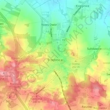
Name: Trzebnica topographic map, elevation, terrain.
Average elevation: 195 m
Minimum elevation: 139 m
Maximum elevation: 259 m
Other topographic maps
Click on a map to view its topography, its elevation and its terrain.
Sienna
Poland > Lower Silesian Voivodeship > Trzebnica County > Rościsławice
Sienna, Rościsławice, gmina Oborniki Śląskie, Trzebnica County, Lower Silesian Voivodeship, Poland
Average elevation: 161 m