
Gerlachovský štít topographic map
Interactive map
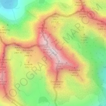
Click on the map to display elevation.
About this map
Name: Gerlachovský štít topographic map, elevation, terrain.
Average elevation: 2,103 m
Minimum elevation: 1,571 m
Maximum elevation: 2,618 m
Gerlachovský štít (Slovak pronunciation (help·info), translated into English as Gerlachov Peak, German: Gerlsdorfer Spitze, Hungarian: Gerlachfalvi-csúcs), informally referred to as Gerlach, is the highest peak in the High Tatras, in Slovakia, and in the Carpathian Mountains. Its elevation is usually listed at 2654.4 m above mean sea level. The pyramidal shape of the massif is marked by a huge cirque. Despite its relatively low elevation, Gerlachovský štít features a vertical rise of approximately 2,000 metres (6,600 ft) above the valley floor.
Other topographic maps
Click on a map to view its topography, its elevation and its terrain.
Kriváň
Slovakia > Region of Prešov > District of Poprad > Vysoké Tatry
Kriváň, Vysoké Tatry, District of Poprad, Region of Prešov, Eastern Slovakia, Slovakia
Average elevation: 1,913 m