
Highland topographic map
Interactive map
Click on the map to display elevation.
About this map
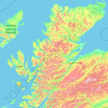
Name: Highland topographic map, elevation, terrain.
Location: Highland, Escocia, Gran Bretaña (56.49715 -6.78982 58.69651 -3.02396)
Average elevation: 183 m
Minimum elevation: -1 m
Maximum elevation: 1,285 m
Other topographic maps
Click on a map to view its topography, its elevation and its terrain.
Edimburgo
Gran Bretaña > Escocia > Edimburgo
Edimburgo, City of Edinburgh, Escocia, EH1 3EG, Gran Bretaña
Average elevation: 104 m
Aberdeen
Gran Bretaña > Escocia > Aberdeen
Aberdeen, Aberdeen City, Escocia, AB11 5EQ, Gran Bretaña
Average elevation: 52 m
Milngavie
Gran Bretaña > Escocia > Milngavie
Milngavie, East Dunbartonshire, Escocia, G62 6BH, Gran Bretaña
Average elevation: 99 m
Newmains
Gran Bretaña > Escocia > Newmains
Newmains, North Lanarkshire, Escocia, ML2 9EY, Gran Bretaña
Average elevation: 163 m
Peebles
Gran Bretaña > Escocia > Peebles
Peebles, Scottish Borders, Escocia, EH45 8SL, Gran Bretaña
Average elevation: 275 m