
Narragansett topographic map
Interactive map
Click on the map to display elevation.
About this map
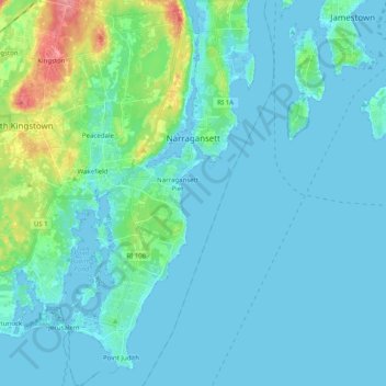
Name: Narragansett topographic map, elevation, terrain.
Average elevation: 12 m
Minimum elevation: -5 m
Maximum elevation: 87 m
Other topographic maps
Click on a map to view its topography, its elevation and its terrain.
Sandy Point
United States > Rhode Island > South County > Westerly
Sandy Point, Westerly, South County, Rhode Island, United States
Average elevation: 1 m
Richmond
United States > Rhode Island > South County
Richmond, South County, Rhode Island, United States
Average elevation: 56 m
North Kingstown
United States > Rhode Island > South County
North Kingstown, South County, Rhode Island, United States
Average elevation: 35 m
Kenyon
United States > Rhode Island > South County > Richmond > Kenyon
Kenyon, Richmond, South County, Rhode Island, 02836, United States
Average elevation: 41 m
West Kingston
United States > Rhode Island > South County > South Kingstown > West Kingston
West Kingston, South Kingstown, South County, Rhode Island, 02881, United States
Average elevation: 41 m
Cummock Island
United States > Rhode Island > South County > South Kingstown
Cummock Island, South Kingstown, South County, Rhode Island, United States
Average elevation: 9 m
South Kingstown
United States > Rhode Island > South County
South Kingstown, South County, Rhode Island, United States
Average elevation: 30 m