
Borger-Odoorn topographic map
Interactive map
Click on the map to display elevation.
About this map
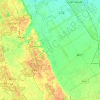
Name: Borger-Odoorn topographic map, elevation, terrain.
Location: Borger-Odoorn, Drenthe, Netherlands, The Netherlands (52.80463 6.72418 52.99334 7.04557)
Average elevation: 14 m
Minimum elevation: 2 m
Maximum elevation: 29 m
Dutch Topographic map of the municipality of Borger-Odoorn, June 2015.
Other topographic maps
Click on a map to view its topography, its elevation and its terrain.
Valthermond
The Netherlands > Drenthe > Borger-Odoorn
Valthermond, Borger-Odoorn, Drenthe, Netherlands, The Netherlands
Average elevation: 10 m