
Kollam topographic map
Interactive map
Click on the map to display elevation.
About this map
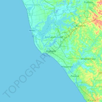
Name: Kollam topographic map, elevation, terrain.
Location: Kollam, Kollam District, Kerala, 691001, India (8.72795 76.43550 9.04795 76.75550)
Average elevation: 12 m
Minimum elevation: -2 m
Maximum elevation: 122 m
Cosmas Indicopleustes, a Greek Nestorian sailor, in his book the Christian Topography who visited the Malabar Coast in 550, mentions an enclave of Christian believers in Male (Malabar Coast). He writes, "In the island of Tabropane (Ceylon), there is a church of Christians, and clerics and faithful. Likewise at Male, where the pepper grows, and in the farming community of Kalliana (Kalliankal at Nillackal) there is also a bishop consecrated in Persia in accordance with the Nicea Sunnahadose of 325 AD." The Nestorian Patriarch Jesujabus, who died in 660 AD, mentions Kollam in his letter to Simon, Metropolitan of Persia.
Other topographic maps
Click on a map to view its topography, its elevation and its terrain.