
Exeter topographic map
Interactive map
Click on the map to display elevation.
About this map
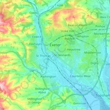
Name: Exeter topographic map, elevation, terrain.
Location: Exeter, Devon, England, United Kingdom (50.67318 -3.57020 50.76147 -3.45116)
Average elevation: 56 m
Minimum elevation: -3 m
Maximum elevation: 218 m
The city of Exeter was established on the eastern bank of the River Exe on a ridge of land backed by a steep hill. It is at this point that the Exe, having just been joined by the River Creedy, opens onto a wide flood plain and estuary which results in quite common flooding. Historically this was the lowest bridging point of the River Exe which was tidal and navigable up to the city until the construction of weirs later in its history. This combined with the easily defensible higher ground of the ridge made the current location of the city a natural choice for settlement and trade. In George Oliver's The History of the City of Exeter, it is noted that the most likely reasons for the original settling of what would become modern Exeter was the "fertility of the surrounding countryside" and the area's "beautiful and commanding elevation its rapid and navigable river". Its woodland would also have been ideal for natural resources and hunting.
Other topographic maps
Click on a map to view its topography, its elevation and its terrain.
Orway
United Kingdom > England > Devon > Mid Devon > Saint Hill
Orway, Kentisbeare, Saint Hill, Mid Devon, Devon, England, EX15 2EX, United Kingdom
Average elevation: 155 m
Poltimore
United Kingdom > England > Devon > East Devon
Poltimore, East Devon, Devon, England, United Kingdom
Average elevation: 34 m
Woodleigh
United Kingdom > England > Devon > South Hams
Woodleigh, South Hams, Devon, England, United Kingdom
Average elevation: 108 m
Exmouth
United Kingdom > England > Devon > East Devon
Exmouth, East Devon, Devon, England, United Kingdom
Average elevation: 29 m
Strete
United Kingdom > England > Devon > South Hams
Strete, South Hams, Devon, England, United Kingdom
Average elevation: 65 m
Tavistock
United Kingdom > England > Devon > West Devon
Tavistock, West Devon, Devon, England, United Kingdom
Average elevation: 139 m
West Down
United Kingdom > England > Devon > North Devon
West Down, North Devon, Devon, England, United Kingdom
Average elevation: 178 m
North Devon
United Kingdom > England > Devon
North Devon, Devon, England, United Kingdom
Average elevation: 156 m
Water
United Kingdom > England > Devon > Teignbridge > Water
Water, Teignbridge, Devon, South West England, England, TQ13 9UE, United Kingdom
Average elevation: 261 m
Spire's Lake
United Kingdom > England > Devon > West Devon > Sampford Courtenay
Spire's Lake, Sampford Courtenay, West Devon, Devon, England, EX20 2SG, United Kingdom
Average elevation: 147 m
Dunsford
United Kingdom > England > Devon > Teignbridge
Dunsford, Teignbridge, Devon, England, EX6 7AA, United Kingdom
Average elevation: 139 m
Thornbury
United Kingdom > England > Devon > Torridge District
Thornbury, Torridge District, Devon, England, United Kingdom
Average elevation: 133 m
Whitestone
United Kingdom > England > Devon > Teignbridge
Whitestone, Teignbridge, Devon, England, United Kingdom
Average elevation: 104 m
Dartmouth
United Kingdom > England > Devon > South Hams > Kingswear
Dartmouth, Kingswear, South Hams, Devon, England, United Kingdom
Average elevation: 71 m
Teignbridge
United Kingdom > England > Devon > Teignbridge
Teignbridge, Devon, England, United Kingdom
Average elevation: 140 m
Bidwell
United Kingdom > England > Devon > Mid Devon > Thorverton
Bidwell, Thorverton, Mid Devon, Devon, England, EX5 5LJ, United Kingdom
Average elevation: 88 m