
Newport County topographic map
Interactive map
Click on the map to display elevation.
About this map
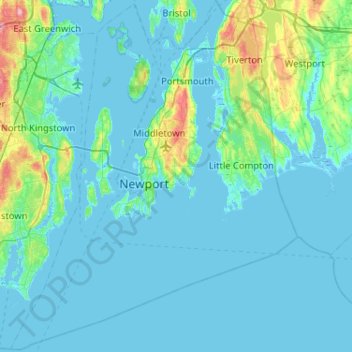
Name: Newport County topographic map, elevation, terrain.
Location: Newport County, Rhode Island, United States (41.30736 -71.50944 41.69050 -71.08857)
Average elevation: 14 m
Minimum elevation: -7 m
Maximum elevation: 130 m
The county consists of Aquidneck Island, Conanicut Island, Prudence Island, and the easternmost portion of the state on the mainland. The highest point in the county is Pocasset Hill, 320 feet (98 m) above sea level, located in Tiverton. The lowest elevation is at sea level.
Other topographic maps
Click on a map to view its topography, its elevation and its terrain.
Sandy Point
United States > Rhode Island > South County > Westerly
Sandy Point, Westerly, South County, Rhode Island, United States
Average elevation: 1 m
Richmond
United States > Rhode Island > South County
Richmond, South County, Rhode Island, United States
Average elevation: 56 m
Greenville
United States > Rhode Island > Providence County > Greenville
Greenville, Providence County, Rhode Island, 02828, United States
Average elevation: 98 m
Foster
United States > Rhode Island > Providence County
Foster, Providence County, Rhode Island, 02825, United States
Average elevation: 171 m
Newport
United States > Rhode Island > Newport County
Newport, Newport County, Rhode Island, 02840, United States
Average elevation: 8 m
West Warwick
United States > Rhode Island > Kent County
West Warwick, Kent County, Rhode Island, 02893, United States
Average elevation: 60 m
North Kingstown
United States > Rhode Island > South County
North Kingstown, South County, Rhode Island, United States
Average elevation: 35 m
Maple Road
United States > Rhode Island > Bristol County > Warren
Maple Road, Warren, Bristol County, Rhode Island, United States
Average elevation: 4 m
South County
South County, Rhode Island, United States
Average elevation: 30 m
Little Compton
United States > Rhode Island > Newport County
Little Compton, Newport County, Rhode Island, United States
Average elevation: 9 m
Westerly
United States > Rhode Island > Washington County
Westerly, Washington County, Rhode Island, 02808, United States
Average elevation: 19 m
West Greenwich
United States > Rhode Island > Kent County
West Greenwich, Kent County, Rhode Island, 02817, United States
Average elevation: 111 m
Central Falls
United States > Rhode Island > Central Falls
Central Falls, Providence County, Rhode Island, United States
Average elevation: 22 m
Kenyon
United States > Rhode Island > South County > Richmond > Kenyon
Kenyon, Richmond, South County, Rhode Island, 02836, United States
Average elevation: 41 m
Providence
United States > Rhode Island > Providence County
Providence, Providence County, Rhode Island, United States
Average elevation: 19 m
West Kingston
United States > Rhode Island > South County > South Kingstown > West Kingston
West Kingston, South Kingstown, South County, Rhode Island, 02881, United States
Average elevation: 41 m
Kent County
Kent County, Rhode Island, United States
Average elevation: 92 m
Cummock Island
United States > Rhode Island > South County > South Kingstown
Cummock Island, South Kingstown, South County, Rhode Island, United States
Average elevation: 9 m
Woonsocket
United States > Rhode Island > Providence County
Woonsocket, Providence County, Rhode Island, 02895, United States
Average elevation: 74 m
Narragansett
United States > Rhode Island > South County
Narragansett, South County, Rhode Island, 02882, United States
Average elevation: 12 m
East Greenwich
United States > Rhode Island > Kent County
East Greenwich, Kent County, Rhode Island, 02818, United States
Average elevation: 21 m
South Kingstown
United States > Rhode Island > South County
South Kingstown, South County, Rhode Island, United States
Average elevation: 30 m
Providence County
Providence County, Rhode Island, United States
Average elevation: 108 m
Cranston
United States > Rhode Island > Providence County
Cranston, Providence County, Rhode Island, United States
Average elevation: 27 m