Geolocate

Iquitos topographic map

Interactive map

Click on the map to display elevation.

About this map

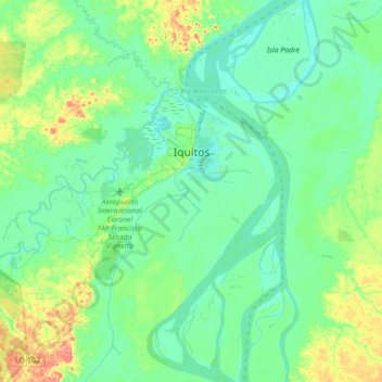
Name: Iquitos topographic map, elevation, terrain.

Location: Iquitos, Province of Maynas, Loreto, Peru (-3.88645 -73.59096 -3.68525 -73.23643)

Average elevation: 94 m

Minimum elevation: 78 m

Maximum elevation: 146 m

Other topographic maps

Click on a map to view its topography, its elevation and its terrain.

Province of Maynas

Peru > Loreto

Province of Maynas, Loreto, Peru

Average elevation: 128 m

Santa Fe

Peru > Loreto > Emilio San Martín

Santa Fe, Emilio San Martín, Province of Requena, Loreto, Peru

Average elevation: 103 m

Río Zungaro

Peru > Loreto

Río Zungaro, Province of Requena, Loreto, Peru

Average elevation: 122 m

Province of Maynas

Peru > Loreto

Province of Maynas, Loreto, Peru

Average elevation: 140 m

Santander

Peru > Loreto > Pastaza

Santander, Pastaza, Province of Datem del Marañón, Loreto, Peru

Average elevation: 134 m

Maynas

Peru > Loreto > Maynas

Maynas, Province of Maynas, Loreto, Peru

Average elevation: 100 m

Province of Maynas

Peru > Loreto > Mazán

Province of Maynas, Mazán, Maynas, Loreto, Peru

Average elevation: 107 m

Putumayo

Peru > Loreto

Putumayo, Loreto, Peru

Average elevation: 163 m