
Crown Point topographic map
Interactive map
Click on the map to display elevation.
About this map
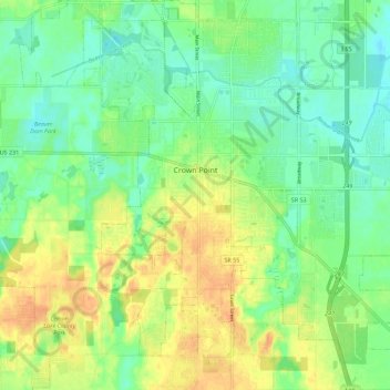
Name: Crown Point topographic map, elevation, terrain.
Location: Crown Point, Lake County, Indiana, 46307, United States (41.36921 -87.39758 41.45373 -87.29672)
Average elevation: 220 m
Minimum elevation: 204 m
Maximum elevation: 240 m
Other topographic maps
Click on a map to view its topography, its elevation and its terrain.
Griffith
United States > Indiana > Lake County
Griffith, Lake County, Indiana, 46319, United States
Average elevation: 190 m
Merrillville
United States > Indiana > Lake County > Merrillville
Merrillville, Lake County, Indiana, 46410, United States
Average elevation: 204 m
Gary
United States > Indiana > Lake County > Gary
Gary, Lake County, Indiana, 46402, United States
Average elevation: 187 m