
Conques-en-Rouergue topographic map
Interactive map
Click on the map to display elevation.
About this map
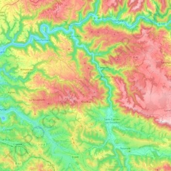
Name: Conques-en-Rouergue topographic map, elevation, terrain.
Average elevation: 415 m
Minimum elevation: 186 m
Maximum elevation: 704 m
Other topographic maps
Click on a map to view its topography, its elevation and its terrain.
Cadres
France > Occitania > Conques-en-Rouergue
Cadres, Saint-Cyprien-sur-Dourdou, Conques-en-Rouergue, Rodez, Aveyron, Occitania, Metropolitan France, 12320, France
Average elevation: 354 m