
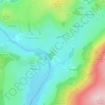
Haugh topographic map
Interactive map
Click on the map to display elevation.
About this map
Name: Haugh topographic map, elevation, terrain.
Average elevation: 215 m
Minimum elevation: 122 m
Maximum elevation: 443 m
Other topographic maps
Click on a map to view its topography, its elevation and its terrain.
Craven
United Kingdom > England > Craven
Craven, North Yorkshire, Yorkshire and the Humber, England, United Kingdom
Average elevation: 294 m
High Springs
United Kingdom > England > Craven
High Springs, Craven, North Yorkshire, Yorkshire and the Humber, England, LA6 3AT, United Kingdom
Average elevation: 408 m
Lothersdale
United Kingdom > England > Craven
Lothersdale, Craven, North Yorkshire, Yorkshire and the Humber, England, United Kingdom
Average elevation: 273 m