
El Carmen topographic map
Interactive map
Click on the map to display elevation.
About this map
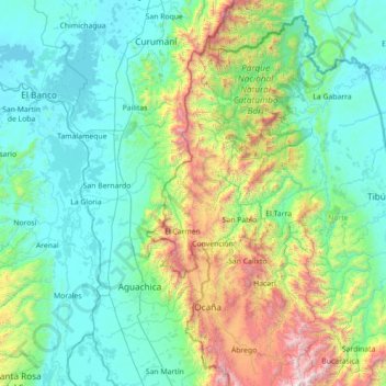
Name: El Carmen topographic map, elevation, terrain.
Location: El Carmen, Norte de Santander, Colombia (8.00731 -74.04820 9.28731 -72.76820)
Average elevation: 542 m
Minimum elevation: 19 m
Maximum elevation: 2,821 m
Other topographic maps
Click on a map to view its topography, its elevation and its terrain.
Perímetro Urbano Cúcuta
Colombia > Norte de Santander > Cúcuta
Perímetro Urbano Cúcuta, Cúcuta, Oriental, Norte de Santander, RAP Gran Santander, Colombia
Average elevation: 314 m
Los Caobos;British Pub
Colombia > Norte de Santander > Cúcuta > Los Caobos;British Pub
Los Caobos;British Pub, Cúcuta, Norte de Santander, 540006, Colombia
Average elevation: 342 m
Los olivos
Colombia > Norte de Santander > Cúcuta
Los olivos, Cúcuta, Norte de Santander, 540013, Colombia
Average elevation: 287 m