
Leipziger Straße topographic map
Interactive map
Click on the map to display elevation.
About this map
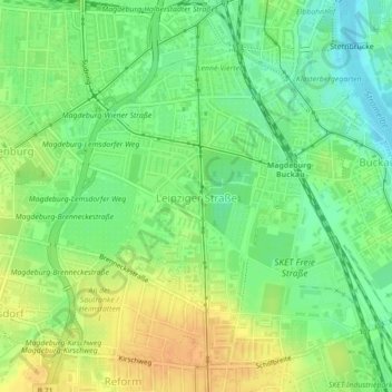
Name: Leipziger Straße topographic map, elevation, terrain.
Location: Leipziger Straße, Magdeburg, Saxony-Anhalt, Germany (52.09352 11.60356 52.11906 11.63835)
Average elevation: 59 m
Minimum elevation: 43 m
Maximum elevation: 75 m
Other topographic maps
Click on a map to view its topography, its elevation and its terrain.
Magdeburg
Germany > Saxony-Anhalt > Magdeburg
Magdeburg, Saxony-Anhalt, 39104, Germany
Average elevation: 71 m