
Cantón San José topographic map
Interactive map
Click on the map to display elevation.
About this map
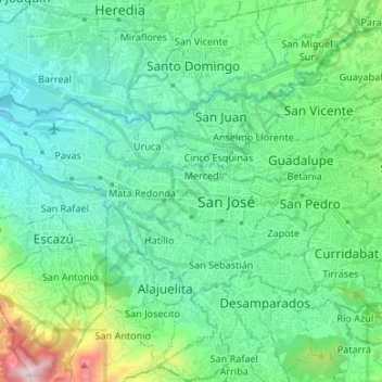
Name: Cantón San José topographic map, elevation, terrain.
Location: Cantón San José, Provincia San José, Costa Rica (9.89988 -84.18003 9.97203 -84.04680)
Average elevation: 1,197 m
Minimum elevation: 936 m
Maximum elevation: 2,249 m
Other topographic maps
Click on a map to view its topography, its elevation and its terrain.
Catedral
Costa Rica > Provincia San José > Catedral
Catedral, Cantón San José, Provincia San José, 10104, Costa Rica
Average elevation: 1,155 m