
Watford topographic map
Interactive map
Click on the map to display elevation.
About this map
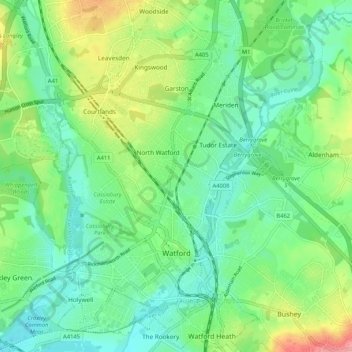
Name: Watford topographic map, elevation, terrain.
Location: Watford, Hertfordshire, England, United Kingdom (51.63709 -0.43957 51.70200 -0.36884)
Average elevation: 77 m
Minimum elevation: 45 m
Maximum elevation: 149 m
Other topographic maps
Click on a map to view its topography, its elevation and its terrain.
Baldock
United Kingdom > England > Hertfordshire > North Hertfordshire
Baldock, North Hertfordshire, Hertfordshire, England, SG7 6AS, United Kingdom
Average elevation: 90 m
Hatfield
United Kingdom > England > Hertfordshire > Welwyn Hatfield
Hatfield, Welwyn Hatfield, Hertfordshire, England, United Kingdom
Average elevation: 90 m
Hammond Street
United Kingdom > England > Hertfordshire > Broxbourne
Hammond Street, Broxbourne, Hertfordshire, England, EN7 6WH, United Kingdom
Average elevation: 83 m
Verulamium Lake
United Kingdom > England > Hertfordshire > St Albans
Verulamium Lake, St Stephens, St Albans, Hertfordshire, England, United Kingdom
Average elevation: 102 m
Tyttenhanger
United Kingdom > England > Hertfordshire > St Albans > Colney Heath
Tyttenhanger, Colney Heath, St Albans, Hertfordshire, England, AL4 0RN, United Kingdom
Average elevation: 83 m
Hertford Heath
United Kingdom > England > Hertfordshire > East Hertfordshire
Hertford Heath, East Hertfordshire, Hertfordshire, England, United Kingdom
Average elevation: 74 m
St Albans
United Kingdom > England > Hertfordshire
St Albans, Hertfordshire, England, United Kingdom
Average elevation: 103 m
Ware
United Kingdom > England > Hertfordshire > East Hertfordshire
Ware, East Hertfordshire, Hertfordshire, England, United Kingdom
Average elevation: 55 m
Tring
United Kingdom > England > Hertfordshire > Dacorum
Tring, Dacorum, Hertfordshire, England, United Kingdom
Average elevation: 168 m
Stevenage
United Kingdom > England > Hertfordshire
Stevenage, Hertfordshire, England, United Kingdom
Average elevation: 108 m
Stanstead Abbotts
United Kingdom > England > Hertfordshire > East Hertfordshire
Stanstead Abbotts, East Hertfordshire, Hertfordshire, England, SG12 8HU, United Kingdom
Average elevation: 48 m
Letchworth
United Kingdom > England > Hertfordshire
Letchworth, Hertfordshire, England, United Kingdom
Average elevation: 81 m
Bishop's Stortford
United Kingdom > England > Hertfordshire > East Hertfordshire
Bishop's Stortford, East Hertfordshire, Hertfordshire, England, United Kingdom
Average elevation: 83 m
Norton
United Kingdom > England > Hertfordshire > Letchworth
Norton, Letchworth, Hertfordshire, England, SG6 1AG, United Kingdom
Average elevation: 75 m
Middlesex
United Kingdom > England > Hertfordshire
Middlesex, Hertfordshire, Greater London, England, United Kingdom
Average elevation: 46 m
Bovingdon
United Kingdom > England > Hertfordshire > Bovingdon
Bovingdon, Hertfordshire, East of England, England, HP3 0FA, United Kingdom
Average elevation: 150 m
Bushey Heath
United Kingdom > England > Hertfordshire > Hertsmere > Bushey Heath
Bushey Heath, Hertsmere, Hertfordshire, East of England, England, WD23 1SH, United Kingdom
Average elevation: 110 m
Royston
United Kingdom > England > Hertfordshire > North Hertfordshire
Royston, North Hertfordshire, Hertfordshire, England, United Kingdom
Average elevation: 78 m
St Albans
United Kingdom > England > Hertfordshire > St Albans
St Albans, Hertfordshire, East of England, England, United Kingdom
Average elevation: 107 m
Barkway
United Kingdom > England > Hertfordshire > North Hertfordshire
Barkway, North Hertfordshire, Hertfordshire, England, United Kingdom
Average elevation: 119 m
Letchworth
United Kingdom > England > Hertfordshire > North Hertfordshire > Letchworth
Letchworth, North Hertfordshire, Hertfordshire, East of England, England, SG6 3BF, United Kingdom
Average elevation: 80 m