
Bellevigne-les-Châteaux topographic map
Interactive map
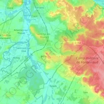
Click on the map to display elevation.
About this map
Name: Bellevigne-les-Châteaux topographic map, elevation, terrain.
Average elevation: 55 m
Minimum elevation: 22 m
Maximum elevation: 118 m
Other topographic maps
Click on a map to view its topography, its elevation and its terrain.
Brézé
France > Pays de la Loire > Bellevigne-les-Châteaux
Brézé, Bellevigne-les-Châteaux, Saumur, Maine-et-Loire, Pays de la Loire, Metropolitan France, 49260, France
Average elevation: 44 m