
Irchester topographic map
Interactive map
Click on the map to display elevation.
About this map
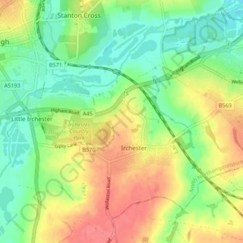
Name: Irchester topographic map, elevation, terrain.
Average elevation: 62 m
Minimum elevation: 32 m
Maximum elevation: 98 m
The 12th-century English historian Henry of Huntingdon mentions a Roman "town on the river (Nene), in Huntingdonshire, which is entirely destroyed" as one of his interpretations of the 28 cities of Britain. The town is mentioned also by William Lambarde in Dictionarium Angliae Topographicum & Historicum.