
Galway Bay topographic map
Interactive map
Click on the map to display elevation.
About this map
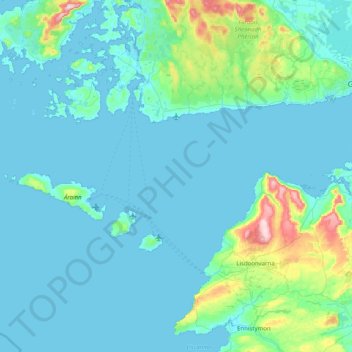
Name: Galway Bay topographic map, elevation, terrain.
Location: Galway Bay, County Galway, Connacht, Ireland (53.03502 -9.78882 53.26172 -8.98750)
Average elevation: 35 m
Minimum elevation: -2 m
Maximum elevation: 346 m
Other topographic maps
Click on a map to view its topography, its elevation and its terrain.
Cleggan
Cleggan, Conamara Municipal District, County Galway, Connacht, H71 HY36, Ireland
Average elevation: 29 m
Lough Loung
Lough Loung, Ballynakill ED, Ballinasloe Municipal District, County Galway, Connacht, Ireland
Average elevation: 65 m
Aughrim
Aughrim, Ballinasloe Municipal District, County Galway, Connacht, Ireland
Average elevation: 68 m
Loughrea
Loughrea, Loughrea Urban ED, Loughrea Municipal District, County Galway, Connacht, Ireland
Average elevation: 88 m
Athenry-Oranmore Municipal District
Athenry-Oranmore Municipal District, County Galway, Connacht, Ireland
Average elevation: 43 m
Galway City
Ireland > County Galway > Galway City
Galway City, County Galway, Connacht, Ireland
Average elevation: 15 m
Highpark
Highpark, Grange ED, Loughrea Municipal District, County Galway, Connacht, Ireland
Average elevation: 102 m
Crowsnest
Crowsnest, Lismanny ED, Ballinasloe Municipal District, County Galway, Connacht, Ireland
Average elevation: 67 m