
Haifa topographic map
Interactive map
Click on the map to display elevation.
About this map
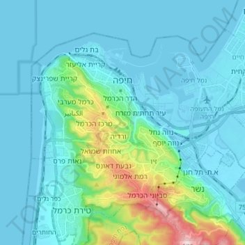
Name: Haifa topographic map, elevation, terrain.
Location: Haifa, Haifa Subdistrict, Haifa District, Israel (32.75795 34.94997 32.84270 35.07974)
Average elevation: 74 m
Minimum elevation: -4 m
Maximum elevation: 526 m
Haifa is the center of liberal Arabic-speaking culture, as it was under British colonial rule. The Arabic-speaking neighborhoods, which are mixed Muslim and Christian, are in the lowlands near the sea, while Jewish neighborhoods are at higher elevation. An active Arab cultural life has developed in the 21st century. The city is center of many Arab-owned businesses such as theaters, bars, cafes, restaurants and nightclubs which host also a different cultural discussions and art exhibitions.
Other topographic maps
Click on a map to view its topography, its elevation and its terrain.
Zikhron Yaakov
Zikhron Yaakov, Hadera Subdistrict, Haifa District, Israel
Average elevation: 53 m
Tirat Karmel
Tirat Karmel, Haifa Subdistrict, Haifa District, 3955022, Israel
Average elevation: 76 m
Kiryat Ata
Israel > Haifa District > Kiryat Ata
Kiryat Ata, Haifa Subdistrict, Haifa District, 2820313, Israel
Average elevation: 39 m
Hadera
Israel > Haifa District > Hadera
Hadera, Hadera Subdistrict, Haifa District, Israel
Average elevation: 20 m