
Serres topographic map
Interactive map
Click on the map to display elevation.
About this map
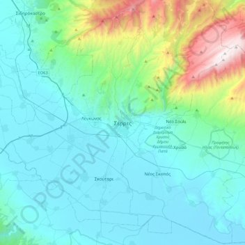
Name: Serres topographic map, elevation, terrain.
Average elevation: 317 m
Minimum elevation: -1 m
Maximum elevation: 1,951 m
Serres is one of the administrative and economic centers of Northern Greece. The city is situated in a fertile plain at an elevation of about 70 metres (230 feet), some 24 kilometres (15 miles) northeast of the Strymon river and 69 km (43 mi) north-east of Thessaloniki, respectively. Serres' official municipal population was 76,817 in 2011 with the total number of people living in the city and its immediate surroundings estimated at around 100,000.