
Île Longue topographic map
Interactive map
Click on the map to display elevation.
About this map
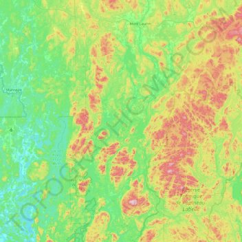
Name: Île Longue topographic map, elevation, terrain.
Average elevation: 271 m
Minimum elevation: 139 m
Maximum elevation: 600 m
Other topographic maps
Click on a map to view its topography, its elevation and its terrain.
31 Mile Lake
Canada > Quebec > Antoine-Labelle > Notre-Dame-de-Pontmain
31 Mile Lake, Notre-Dame-de-Pontmain, Antoine-Labelle, Laurentides, Quebec, Canada
Average elevation: 173 m