
Gwari topographic map
Interactive map
Click on the map to display elevation.
About this map
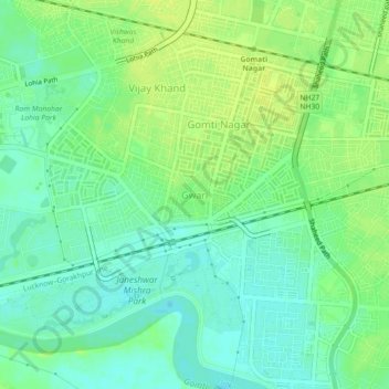
Name: Gwari topographic map, elevation, terrain.
Location: Gwari, Lucknow, Lucknow District, Uttar Pradesh, 226010, India (26.82561 80.97607 26.86561 81.01607)
Average elevation: 113 m
Minimum elevation: 104 m
Maximum elevation: 121 m
Other topographic maps
Click on a map to view its topography, its elevation and its terrain.
Lucknow
India > Uttar Pradesh > Lucknow
Lucknow, Lucknow District, Uttar Pradesh, 226027, India
Average elevation: 120 m
Vikram Nagar
India > Uttar Pradesh > Lucknow
Vikram Nagar, Lucknow, Lucknow District, Uttar Pradesh, 226008, India
Average elevation: 124 m
Tiwariganj
India > Uttar Pradesh > Lucknow
Tiwariganj, Lucknow, Lucknow District, Uttar Pradesh, 226028, India
Average elevation: 117 m
बड़ा भरवांरा
India > Uttar Pradesh > Lucknow
बड़ा भरवांरा, Lucknow, Uttar Pradesh, 227105, India
Average elevation: 115 m