
Fairy Lake topographic map
Interactive map
Click on the map to display elevation.
About this map
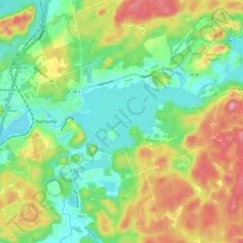
Name: Fairy Lake topographic map, elevation, terrain.
Average elevation: 327 m
Minimum elevation: 275 m
Maximum elevation: 405 m
Other topographic maps
Click on a map to view its topography, its elevation and its terrain.
Muskoka River
Canada > Ontario > Muskoka District > Huntsville
Muskoka River, Huntsville, District Municipality of Muskoka, Muskoka District, Central Ontario, Ontario, Canada
Average elevation: 316 m
Lake Vernon
Canada > Ontario > Muskoka District > Huntsville
Lake Vernon, Huntsville, District Municipality of Muskoka, Muskoka District, Central Ontario, Ontario, P1H 2J2, Canada
Average elevation: 294 m
Waseosa Lake
Canada > Ontario > Muskoka District > Huntsville
Waseosa Lake, Huntsville, District Municipality of Muskoka, Muskoka District, Central Ontario, Ontario, Canada
Average elevation: 354 m
Axe Lake
Canada > Ontario > Muskoka District > Huntsville
Axe Lake, Huntsville, District Municipality of Muskoka, Muskoka District, Central Ontario, Ontario, Canada
Average elevation: 326 m