
Warsaw topographic map
Interactive map
Click on the map to display elevation.
About this map
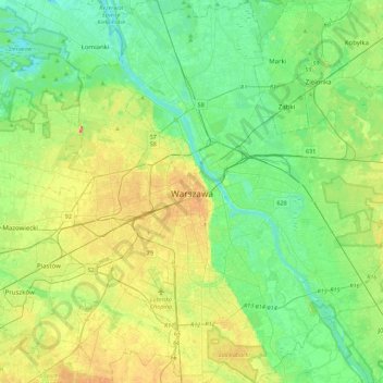
Name: Warsaw topographic map, elevation, terrain.
Location: Warsaw, Masovian Voivodeship, Poland (52.09785 20.85169 52.36815 21.27115)
Average elevation: 95 m
Minimum elevation: 71 m
Maximum elevation: 146 m
Warsaw lies in east-central Poland about 300 km (190 mi) from the Carpathian Mountains and about 260 km (160 mi) from the Baltic Sea, 523 km (325 mi) east of Berlin, Germany. The city straddles the Vistula River. It is located in the heartland of the Masovian Plain, and its average elevation is 100 metres (330 ft) above sea level. The highest point on the left side of the city lies at a height of 115.7 metres (379.6 ft) ("Redutowa" bus depot, district of Wola), on the right side – 122.1 metres (400.6 ft) ("Groszówka" estate, district of Wesoła, by the eastern border). The lowest point lies at a height 75.6 metres (248.0 ft) (at the right bank of the Vistula, by the eastern border of Warsaw). There are some hills (mostly artificial) located within the confines of the city – e.g. Warsaw Uprising Hill (121 metres (397.0 ft)) and Szczęśliwice hill (138 metres (452.8 ft) – the highest point of Warsaw in general).
Other topographic maps
Click on a map to view its topography, its elevation and its terrain.
Janów
Poland > Masovian Voivodeship > Radom County > Sławno
Janów, Sławno, gmina Wolanów, Radom County, Masovian Voivodeship, 26-652, Poland
Average elevation: 192 m
Chruślice
Poland > Masovian Voivodeship > Radom County
Chruślice, gmina Wolanów, Radom County, Masovian Voivodeship, Poland
Average elevation: 186 m
Kosów Mniejszy
Poland > Masovian Voivodeship > Radom County > Kosów
Kosów Mniejszy, Kosów, gmina Kowala, Radom County, Masovian Voivodeship, 26-624, Poland
Average elevation: 194 m
Mińsk County
Mińsk County, Masovian Voivodeship, Poland
Average elevation: 143 m
Zaręby
Poland > Masovian Voivodeship > Nowy Dwór Mazowiecki County
Zaręby, gmina Zakroczym, Nowy Dwór Mazowiecki County, Masovian Voivodeship, Poland
Average elevation: 109 m
Bielawa-Nabrzeże
Poland > Masovian Voivodeship > Piaseczno County > Bielawa
Bielawa-Nabrzeże, Bielawa, gmina Konstancin-Jeziorna, Piaseczno County, Masovian Voivodeship, 05-520, Poland
Average elevation: 87 m
Taradajki
Poland > Masovian Voivodeship > Siedlce County > Białki
Taradajki, Białki, gmina Siedlce, Siedlce County, Masovian Voivodeship, 08-110, Poland
Average elevation: 157 m
Błonie
Poland > Masovian Voivodeship > Warsaw West County > Błonie
Błonie, gmina Błonie, Warsaw West County, Masovian Voivodeship, Poland
Average elevation: 90 m
Bojary
Poland > Masovian Voivodeship > Sokołów County > Bojary
Bojary, gmina Kosów Lacki, Sokołów County, Masovian Voivodeship, 08-330, Poland
Average elevation: 101 m
Słup Drugi
Poland > Masovian Voivodeship > Garwolin County > Słup Drugi
Słup Drugi, gmina Borowie, Garwolin County, Masovian Voivodeship, 08-412, Poland
Average elevation: 148 m
Karwowo
Poland > Masovian Voivodeship > Sochaczew County
Karwowo, gmina Sochaczew, Sochaczew County, Masovian Voivodeship, Poland
Average elevation: 80 m
Warsaw
Poland > Masovian Voivodeship > Warsaw
Warsaw, Masovian Voivodeship, Poland
Average elevation: 95 m
Warsaw
Poland > Masovian Voivodeship > Warsaw > Warsaw
Warsaw, Masovian Voivodeship, 00-901, Poland
Average elevation: 95 m
Warsaw
Poland > Masovian Voivodeship > Warsaw
Warsaw, Masovian Voivodeship, Poland
Average elevation: 96 m
Nasielsk
Poland > Masovian Voivodeship > Nasielsk
Nasielsk, gmina Nasielsk, Nowy Dwór Mazowiecki County, Masovian Voivodeship, 06-130, Poland
Average elevation: 115 m
Raszyn
Poland > Masovian Voivodeship > Raszyn
Raszyn, gmina Raszyn, Pruszków County, Masovian Voivodeship, Poland
Average elevation: 106 m
Ostrowiec
Poland > Masovian Voivodeship > Ostrowiec
Ostrowiec, gmina Repki, Sokołów County, Masovian Voivodeship, 08-307, Poland
Average elevation: 145 m
Ryczywół
Poland > Masovian Voivodeship > Ryczywół
Ryczywół, gmina Kozienice, Kozienice County, Masovian Voivodeship, Poland
Average elevation: 106 m
Gorzewo
Poland > Masovian Voivodeship > Gorzewo
Gorzewo, gmina Gostynin, Gostynin County, Masovian Voivodeship, Poland
Average elevation: 88 m
Burlaki
Poland > Masovian Voivodeship > Burlaki
Burlaki, gmina Zatory, Pułtusk County, Masovian Voivodeship, 07-217, Poland
Average elevation: 85 m
Grzędy
Poland > Masovian Voivodeship > Grzędy
Grzędy, gmina Tarczyn, Piaseczno County, Masovian Voivodeship, Poland
Average elevation: 135 m
Osuchów
Poland > Masovian Voivodeship > Osuchów
Osuchów, gmina Promna, Białobrzegi County, Masovian Voivodeship, Poland
Average elevation: 124 m
Pruszków County
Pruszków County, Masovian Voivodeship, Poland
Average elevation: 116 m
Karolewo
Poland > Masovian Voivodeship > Karolewo
Karolewo, gmina Sierpc, Sierpc County, Masovian Voivodeship, 09-200, Poland
Average elevation: 118 m
Starowola
Poland > Masovian Voivodeship > Starowola
Starowola, gmina Jadów, Wołomin County, Masovian Voivodeship, Poland
Average elevation: 102 m
Mława
Poland > Masovian Voivodeship > Mława
Mława, Mława County, Masovian Voivodeship, 06-500, Poland
Average elevation: 153 m
Siedlce County
Siedlce County, Masovian Voivodeship, Poland
Average elevation: 158 m
Ciechanów County
Ciechanów County, Masovian Voivodeship, Poland
Average elevation: 125 m
Wołomin County
Wołomin County, Masovian Voivodeship, Poland
Average elevation: 109 m
Radom County
Radom County, Masovian Voivodeship, Poland
Average elevation: 179 m
Pułtusk County
Pułtusk County, Masovian Voivodeship, Poland
Average elevation: 106 m
Karwowo
Poland > Masovian Voivodeship > Karwowo
Karwowo, Sochaczew, powiat sochaczewski, Masovian Voivodeship, 96-503, Poland
Average elevation: 82 m
Sochaczew
Poland > Masovian Voivodeship > Sochaczew
Sochaczew, powiat sochaczewski, Masovian Voivodeship, Poland
Average elevation: 84 m
Vistula
Poland > Masovian Voivodeship > Mąkosy Stare
Vistula, 3518W, Mąkosy Stare, gmina Jastrzębia, powiat radomski, Masovian Voivodeship, Poland
Average elevation: 127 m
Pionki
Poland > Masovian Voivodeship > Pionki
Pionki, powiat radomski, Masovian Voivodeship, 26-670, Poland
Average elevation: 159 m
Rzechów-Kolonia
Poland > Masovian Voivodeship > Rzechów-Kolonia
Rzechów-Kolonia, gmina Rzeczniów, powiat lipski, Masovian Voivodeship, Poland
Average elevation: 207 m
Żoliborz
Poland > Masovian Voivodeship > Warsaw
Żoliborz, Warsaw, Masovian Voivodeship, Poland
Average elevation: 95 m
Śródmieście
Poland > Masovian Voivodeship > Warsaw
Śródmieście, Warsaw, Masovian Voivodeship, Poland
Average elevation: 101 m
Osuchów
Poland > Masovian Voivodeship > Osuchów
Osuchów, gmina Mszczonów, Żyrardów County, Masovian Voivodeship, 96-323, Poland
Average elevation: 199 m
Sońsk
Poland > Masovian Voivodeship > Ciechanów County
Sońsk, gmina Sońsk, Ciechanów County, Masovian Voivodeship, 06-430, Poland
Average elevation: 107 m
Kaleń
Poland > Masovian Voivodeship > Kaleń
Kaleń, gmina Szczawin Kościelny, powiat gostyniński, Masovian Voivodeship, 09-550, Poland
Average elevation: 105 m
Słup-Kolonia
Poland > Masovian Voivodeship > Słup-Kolonia
Słup-Kolonia, gmina Szulborze Wielkie, powiat ostrowski, Masovian Voivodeship, 07-324, Poland
Average elevation: 125 m
Nowy Duninów
Poland > Masovian Voivodeship > Płock County
Nowy Duninów, gmina Nowy Duninów, Płock County, Masovian Voivodeship, 09-505, Poland
Average elevation: 64 m
Milanówek
Poland > Masovian Voivodeship > Milanówek
Milanówek, Grodzisk Mazowiecki County, Masovian Voivodeship, 05-822, Poland
Average elevation: 102 m
Żyrardów County
Żyrardów County, Masovian Voivodeship, Poland
Average elevation: 138 m
Praga-Południe
Poland > Masovian Voivodeship > Warsaw
Praga-Południe, Warsaw, Warszawa, Masovian Voivodeship, Poland
Average elevation: 86 m
Pułtusk
Poland > Masovian Voivodeship > Pułtusk County
Pułtusk, gmina Pułtusk, Pułtusk County, Masovian Voivodeship, 06-100, Poland
Average elevation: 92 m
Grodzisk Mazowiecki County
Grodzisk Mazowiecki County, Masovian Voivodeship, Poland
Average elevation: 129 m
Pruszków
Poland > Masovian Voivodeship > Pruszków > Pruszków
Pruszków, Pruszków County, Masovian Voivodeship, Poland
Average elevation: 99 m