
Benito Juárez topographic map
Interactive map
Click on the map to display elevation.
About this map
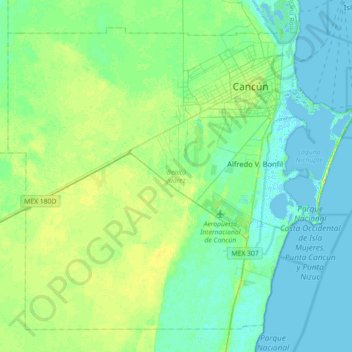
Name: Benito Juárez topographic map, elevation, terrain.
Location: Benito Juárez, Quintana Roo, Mexico (20.72845 -87.32335 21.23177 -86.74054)
Average elevation: 7 m
Minimum elevation: -4 m
Maximum elevation: 21 m
In response to the French invasion and the elevation of Maximilian as Emperor of Mexico, Juárez sent General Plácido Vega y Daza to California to gather Mexican American sympathy for republican Mexico. Maximilian offered Juárez amnesty and later the post of prime minister, but Juárez refused to accept a government "imposed by foreigners," or a monarchy. The US government was sympathetic to Juárez, refusing to recognize Maximilian and opposing the French invasion as a violation of the Monroe Doctrine. Most of its attention was taken up by the American Civil War.
Other topographic maps
Click on a map to view its topography, its elevation and its terrain.
Cancún
Mexico > Quintana Roo > Benito Juárez
Cancún, Benito Juárez, Quintana Roo, Mexico
Average elevation: 5 m