
Central Park topographic map
Interactive map
Click on the map to display elevation.
About this map
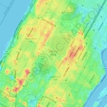
Name: Central Park topographic map, elevation, terrain.
Location: Central Park, New York County, New York, United States (40.76475 -73.98141 40.80031 -73.94961)
Average elevation: 26 m
Minimum elevation: -5 m
Maximum elevation: 65 m
In June 1856, Fernando Wood appointed a "consulting board" of seven people, headed by author Washington Irving, to inspire public confidence in the proposed development. Wood hired military engineer Egbert Ludovicus Viele as the park's chief engineer, tasking him with a topographical survey of the site. The following April, the state legislature passed a bill to authorize the appointment of four Democratic and seven Republican commissioners, who had exclusive control over the planning and construction process. Though Viele had already devised a plan for the park, the commissioners disregarded it and retained him to complete only the topographical surveys. The Central Park Commission began hosting a landscape design contest shortly after its creation. The commission specified that each entry contain extremely detailed specifications, as mandated by the consulting board. Thirty-three firms or organizations submitted plans.
Other topographic maps
Click on a map to view its topography, its elevation and its terrain.
Jackie Robinson Park
United States > New York > New York County > New York
Jackie Robinson Park, Harlem, Manhattan, New York County, New York, United States
Average elevation: 19 m
Manhattan
United States > New York > New York County > New York
Manhattan, New York County, New York, United States
Average elevation: 16 m
Manhattan
United States > New York > New York County > New York
Manhattan, New York County, New York, 10044, United States, Roosevelt Island
Average elevation: 13 m