
Ardennes topographic map
Interactive map
Click on the map to display elevation.
About this map
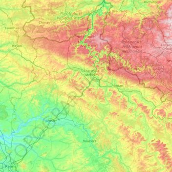
Name: Ardennes topographic map, elevation, terrain.
Location: Ardennes, Grand Est, Metropolitan France, France (49.22685 4.02460 50.16932 5.39407)
Average elevation: 225 m
Minimum elevation: 55 m
Maximum elevation: 574 m
The region was uplifted by a mantle plume during the last few hundred thousand years, as measured from the present elevation of old river terraces.
Other topographic maps
Click on a map to view its topography, its elevation and its terrain.
La Neuville-aux-Joûtes
France > Grand Est > Ardennes > La Neuville-aux-Joûtes
La Neuville-aux-Joûtes, Charleville-Mézières, Ardennes, Grand Est, Metropolitan France, 08380, France
Average elevation: 274 m
Buisson du Loup
France > Grand Est > Ardennes > Les Hautes-Rivières
Buisson du Loup, Les Hautes-Rivières, Charleville-Mézières, Ardennes, Grand Est, Metropolitan France, 08800, France
Average elevation: 260 m